When public evidence becomes a delivery system
Open-source intelligence, or OSINT, is the collection, verification and analysis of publicly accessible or lawfully obtainable information to assess events and actors in a conflict. Its openness gives independent researchers a way to test official accounts. It also gives anyone trying to shape an account a place to plant evidence.
That is the working verdict for conflict coverage: a public feed can serve as a delivery system for a fabricated trail. A state actor seeking a pretext for a preemptive strike could leave material where independent trackers expect to find it, wait for them to publish, then point to their work as apparent corroboration. The tracker becomes part of the claim’s route into the public record.
Public satellite imagery, geolocated photographs, transport records, radio traffic and archived posts can all help establish what happened. None, on its own, identifies who created a contested item. A photograph may place a vehicle on a road while leaving its date uncertain. A radio recording may capture a voice while leaving the transmitter’s location unresolved. Those gaps matter most when an account of troop movement begins to circulate just before a proposed escalation.
The first question has shifted. Finding a hidden detail still takes work, but deciding whether an easy-to-find detail was put there for the analyst now takes equal care. Preserve the original post and its first visible timestamp. Then look back through related material from the preceding 24–72 hours. If the supposedly fresh discovery appeared earlier in a different form, its path may tell you more than its content.
The unencrypted coordinate that spreads everywhere
Picture a regional conflict feed filling with reports of a unit moving toward a border. Several accounts share the same map pin. Someone posts a readable radio exchange that mentions the coordinates. A cropped satellite image follows, annotated to show vehicles near the pin. To a tracker moving quickly, these look like separate observations.
They may all descend from one planted coordinate.
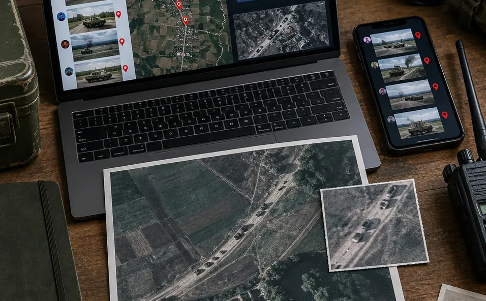
That is the practical problem with digital breadcrumbing. A message left unencrypted can look like an accidental leak. Its coordinates give researchers a search term; a map pin makes the search feel precise; imagery gives the resulting posts visual weight. Repetition across accounts then supplies an illusion of agreement. Before treating the items as witnesses, trace how each one entered the feed.
Start with the earliest available upload time in UTC, the original file URL and the account’s posting history. Save copies of the material as it appeared. Compare later posts for identical wording, image crops and compression artifacts. Those shared features can reveal copying even when captions differ. Next, put the purported transmission time beside the image acquisition time. An image acquired later cannot independently confirm what was visible at an earlier hour.
Civilian-grade receivers and public feeds expose only what reaches them, and sophisticated state actors can anticipate those monitoring methods. A clear transmission therefore establishes what a receiver captured; it does not establish that the transmission escaped by mistake. Silence in civilian monitoring carries a narrower meaning still: it cannot establish that a unit was absent or silent.
The useful finding may be modest. You might confirm that accounts circulated the same coordinates within hours while leaving the coordinates’ origin unresolved. Record that distinction. It prevents a busy feed from turning one unknown source into several apparent confirmations.
How a strike narrative acquires witnesses
What would it take for a questionable image or message to become a public pretext for escalation? Consider two illustrative proxy-conflict scenarios. They describe ways a claim could be assembled, not findings about a particular conflict.
A new date on an old-looking crop
In the first scenario, a cropped satellite screenshot arrives with a date and labels marking a supposed launch site. The annotations invite an immediate conclusion: weapons sit at these coordinates, so a strike is warranted. The source scene is the place to begin testing that conclusion. Compare the crop with an uncropped acquisition and its recorded time. Check cloud cover, road geometry and the positions of persistent structures. If those features disagree, the screenshot needs an explanation before its labels enter a report.
Even a good match has a boundary. Shadows consistent with the claimed time and place can support the scene’s dating and location. They cannot authenticate labels added afterward or identify who wanted researchers to find the image. A verified location and an allegation about its use belong in separate sentences.
A sender name inside a screenshot
In the second scenario, a readable message appears to order a proxy force to move. Its screenshot displays a sender and time, and reposts describe it as intercepted communications. The displayed fields show what the screenshot depicts. Original headers or server records, if obtainable, are needed to test routing and authorship. Without them, the attribution remains unsupported even if the message reached the public feed at the claimed hour.
The thrill of finding such material can compress those distinctions. A tracker recognizes a place name, finds a matching road and publishes before asking who supplied the first file. During the first 24–48 hours after a purported leak, archive revisions and reposts. A later correction may fix the circulating claim, but it will not show which version first drove the allegation unless someone kept it.
Editorially, both scenarios call for the same separation of claims: what the file visibly contains, what independent material supports, and what remains an inference about intent or authorship. That discipline keeps an authentic anomaly from becoming a ready-made explanation for military action.
Build the claim log before the claim travels
A verification baseline gives a reporter a way to challenge a raw claim before its wording hardens across feeds. Preserve the earliest obtainable file, write down precisely what it alleges, and test date, location and provenance as separate questions. Cross-reference metadata across independent platforms; several pages that reproduce one upload still amount to one source.
- Freeze the starting point. Save the file, original URL, first visible posting time and account details. Log relevant material from the preceding 24–72 hours so an earlier version does not disappear beneath reposts.
- Test an image’s clock and place. Compare source-platform acquisition metadata with an independently hosted view of the scene. Inspect building shadows and sun direction against the claimed time and location, then check stable features against the uncropped image. Keep any added labels outside the set of verified image facts.
- Test a message’s route. Retain the original communications file where available. Compare embedded timestamps and time zones with header paths and the first public posting time. If only a screenshot survives, record its displayed sender as a claim rather than an authenticated identity.
- Track the afterlife. Add corrections published in the following 24–48 hours to the claim log. Mark unsupported attribution separately from a verified time or location, and note which apparent confirmations trace back to the same upload.
Open the earliest obtainable file behind the next conflict claim you encounter, record its first visible timestamp, and trace every apparent confirmation back to its original upload before accepting it as an independent source.